Nearly 100,000 Gaza buildings may be damaged, satellite images show
- Published
Satellite images commissioned by the BBC reveal the extent of destruction across Gaza, showing that nearly 98,000 buildings may have suffered damage.
The satellite images were taken last Thursday - before the start of a seven-day suspension of hostilities, which has now ended.
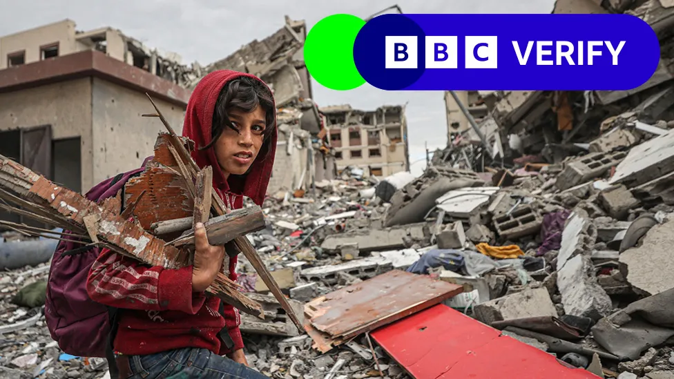
Drone footage and verified video also show buildings and entire neighbourhoods reduced to rubble after Israeli air strikes and on-the-ground fighting.
While northern Gaza has been the focus of the Israeli offensive and has borne the brunt of the destruction, widespread damage extends across the entire strip.
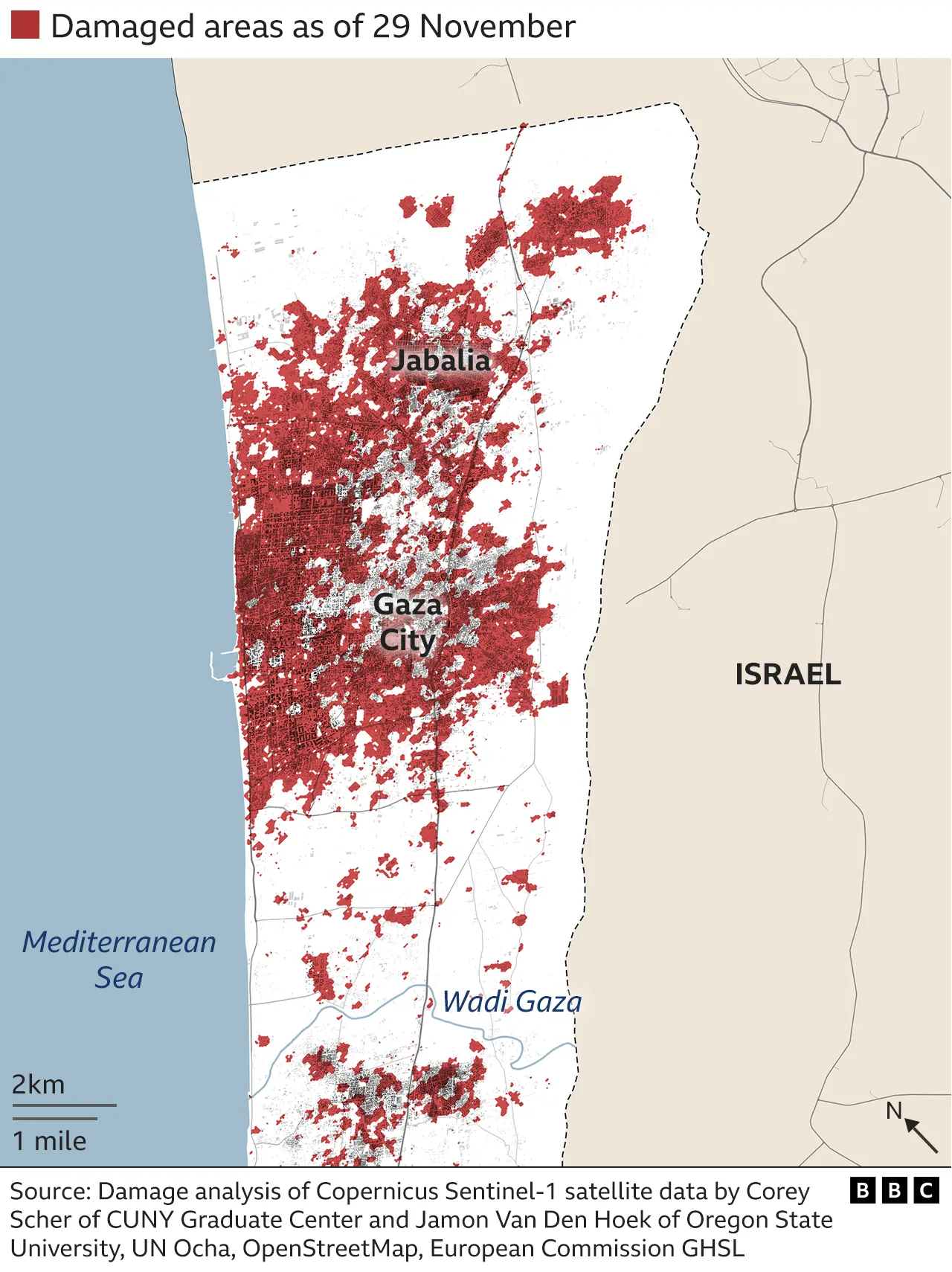
Satellite data maps damage in northern Gaza
Israel says northern Gaza, which includes the major urban centre of Gaza City, was a "centre of gravity of Hamas", the group behind the deadly 7 October attacks on Israel.The Israeli military says its bombing campaign has successfully targeted Hamas commanders and fighters and accuses the group of embedding itself in civilian areas.
Satellite data analysis suggests that almost 98,000 buildings across the whole Gaza Strip may have suffered damage, mostly in the north - as shown in the above map.
Analysis of the data was carried out by Corey Scher of City University of New York Graduate Center and Jamon Van Den Hoek of Oregon State University. It is based on comparisons of two separate images, revealing changes in the height or structure of buildings which suggests damage.
We have analysed satellite imagery from several areas with extensive damage.
North-eastern areas hit by first air strikes
The cities of Beit Lahia and Beit Hanoun in the north and north-east of the Gaza Strip were among the first to be targeted by air strikes after the 7 October attacks by Hamas. The Israel Defense Forces (IDF) said the area was a hideout for Hamas.
Parts of Beit Lahia, which overlooked olive groves and sand dunes stretching towards the border with Israel, were flattened. The satellite image below shows an area in the north-east of Beit Lahia, where a significant block of buildings was destroyed.
Bulldozers appear to have cleared roads through the rubble and the Israeli military cleared land and set up defensive positions in surrounding fields.
Your device may not support this visualisation
The IDF also struck the small nearby city of Beit Hanoun, less than 1.6km (1 mile) from the border. It said 120 targets were hit in the area on the first day of air strikes.

As the images above show, a skyline of multi-storey buildings and a mosquewas gradually reduced to rubble between 14 October and 22 November.
Five-star hotel damaged, nearby neighbourhood flattened
After weeks of air strikes on Gaza, Israel moved in on the ground - tanks and bulldozers going through areas which had been heavily bombarded. The IDF worked its way southwards along the coast towards Shati (Beach) refugee camp, in the Gaza City area.
As the image below shows, a whole series of craters are visible in what was once a residential area. Some of the buildings on the beach front, which boasted Gaza's first five-star hotel, the Al-Mashtal, as well as huts and restaurants, appear to have been partially destroyed.

Satellite analysis shows damage in southern Gaza
About a week after the air strikes began, the IDF warned Palestinians in northern Gaza to move south of a river known as Wadi Gaza for their own safety.
Despite the warning and hundreds of thousands of people fleeing Gaza City, areas in the south continued to be targeted.

Camp buildings destroyed
Nuseirat refugee camp in central Gaza was hit several times before the temporary pause in hostilities began. The camp was said to be home to about 85,000 people, according to the UN.
Airstrikes have destroyed buildings in al-Nuseirat refugee camp area
In this verified video, which emergedonline, people are seen picking through the rubble of collapsed and damaged buildings.
The distinctive black chimney stacks of the Gaza Power Plant, situated just north of the camp, are visible in the background.
The BBC has approached the IDF for comment.
Damage and Israeli orders push a million people to southern Gaza city
In Khan Younis, in southern Gaza, thousands of people are living in tents or the rubble of bombed-out buildings.
Although the damage was not as widespread as in the north, up to 15% of buildings across the city may have been damaged, according to Corey Scher and Jamon Van Den Hoek's analysis.

Israel embeds itself for a long fight
As well as pushing down from the north, Israeli forces also cut across the Gaza Strip westwards, isolating Gaza City from the south.
In this image below, taken to the south of Gaza City, we can see that a previously populated residential area was cleared by the IDF with heavy machinery and a road bulldozed towards the western Mediterranean shoreline.
You can also see dozens of military vehicles, including tanks, grouped behind fortifications made from earth.
Your device may not support this visualisation
Satellite images also show an open square of land with a Star of David carved into the earth by vehicle tracks in Gaza City, near al-Azhar University.
Images online from before the war showed children playing there and suggested it was a park, but IDF spokesman Rear Adm Daniel Hagari said the ground was used by Hamas as a parade square near a base. The area was taken over by the IDF's Golani Brigade.
A Star of David - which is used as a Jewish and Israeli symbol - was made by armoured vehicles in a ceremony in memory of Israeli soldiers who had been killed since the war began, according to a post by Rear Adm Hagari on X.

Additional reporting by Thomas Spencer, Paul Brown, Jake Horton, Alex Murray and Shayan Sardarizadeh and Jemimah Herd

More on Israel-Gaza war
- Follow live: Latest updates
- Hostages: Wounded festival-goer in Hamas video freed
- Prisoners: Released Palestinians allege abuse in Israeli jails
- Explained: Who are the hostages released from Gaza?
- Gaza: Blinken steps up call for Israel to spare civilians
- History behind the story: The Israel-Palestinian conflict
